Southwest, Missouri – A line of severe storms moved across southwest Missouri early Sunday morning, prompting the National Weather Service in Springfield to issue multiple tornado warnings as radar detected rotation in several counties.
The first warning came at 8:25 a.m. CDT for northeastern Barton County, southwestern Cedar County, southeastern Vernon County, and northwestern Dade County.
According to the bulletin, the storm was moving east at 35 mph along a line stretching from near Sheldon to Lamar.
Forecasters warned that flying debris would be dangerous for anyone caught without shelter, and that mobile homes could be damaged or destroyed. Communities in the path included Jerico Springs, Milford, Olympia, Filley, Wagoner, Cedarville, and Sylvania.
By 8:55 a.m., the threat for southwestern Cedar and northwestern Dade counties had eased, and the National Weather Service allowed that warning to expire at 9 a.m. after the storms weakened and moved out of the area.
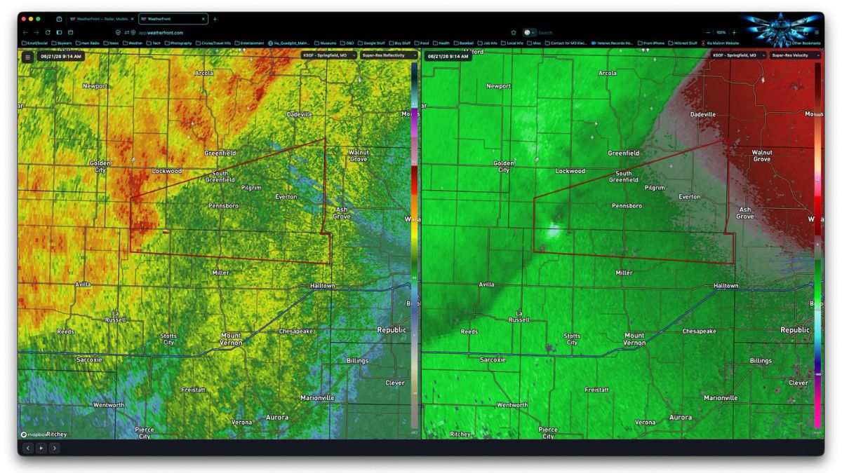
The action shifted east a short time later. At 9:16 a.m., a new tornado warning went up for northern Lawrence County and southern Dade County, set to expire at 10 a.m. The storm responsible was tracked near Lockwood, about 10 miles southwest of Greenfield, again moving east at 35 mph. Towns in the warned path included Everton, South Greenfield, Pennsboro, and Meinert.
A separate alert covered Greene County, where a possible tornado was tracked over Walnut Grove, roughly 14 miles southwest of Bolivar, also moving east at 35 mph. That warning listed Walnut Grove, Morrisville, and Sacville among the locations at risk.
Local Spotters Track Rotation in Real Time
Local meteorologists and storm spotters monitored the system closely as it moved through the region. Jamie Warriner of KOLR/KOZL reported that the warning tied to the circulation east of Walnut Grove was set to expire around 10 a.m., noting that particular rotation had faded.
Attention then turned to a separate area of rotation north of Halltown, which was also moving east. Springfield’s NWS office issued a severe thunderstorm warning for Greene County that included a tornado possibility tag, and spotters said they would continue watching that circulation to see whether it strengthened further.
The Southwest Missouri Skywarn group, along with the City of Springfield and the Springfield-Greene County Office of Emergency Management, also shared updates as the warnings were issued, helping residents track the storm’s progression through the morning.
What Residents Should Know
The National Weather Service reminded residents that a tornado warning means a tornado has either been spotted or indicated by radar, and that those in the path should take cover immediately.
Recommended actions include moving to an interior room on the lowest floor of a sturdy building, staying away from windows, and seeking the nearest substantial shelter if caught in a mobile home, vehicle, or outdoors.
Sunday’s activity followed a pattern of active severe weather across the Ozarks region this season, with the National Weather Service continuing to monitor additional storm development through the morning hours.
Residents in affected counties were urged to stay tuned to local broadcasts and NOAA Weather Radio for updates as the situation evolved.